
Today, the Salt Chuck mine’s rusting ore processing equipment remains mostly in place while the three story mill was (Image 1) removed as part of the CERCLA (Comprehensive Environmental Response and Liability Act) site cleanup in 2011. The Salt Chuck[1] was initially a copper mine but became Alaska’s major producer of palladium[2] after the metal was discovered in the low grade copper ore[3]. The mine was the only producer of palladium in the United States for most of its life[4][5].


Images 1. a.) Abandoned Salt Chuck mine mill equipment, May 17, 2017. (Imaged using 3DR Solo drone/GoPro camera from approximately 50 feet AGL. D. Sylvia); b.) Ground level image of mill site. The equipment was housed in a large wooden building that was removed during the recent site cleanup. (D.Sylvia, 2017)
The mine’s story begins with discovery of the initial ore deposit in 1906 by Silas T. Goodro near a lagoon off Karta Bay. (Karta Bay is located in the extreme northwest part of Kasaan Bay.) While hunting, Goodro stumbled upon an outcropping of bornite, a copper sulfate ore that oxidizes to a conspicuous iridescent peacock blue. Goodro and two of his employees worked the mine in 1906 and early 1907, digging a 12-foot deep surface pit along the vein and driving a 125-foot tunnel. They took out 40 tons of ore and had it tested at the Hadley mine on the north side of the Kasaan Peninsula. This was no small effort as the ore had to be transported a half mile to the beach from whence it would be shipped. Test results indicated that the ore obtained mineable quantities of copper and gold. The results enabled Goodro to obtain financial backing from a J.E. Chilberg[6] (Image 2) and J.M Davidson of Seattle. The next step was to ship a test run of 500 tons of ore to a smelter and, if profitable, additional improvements would be made to the mine.

Image 2. J.E. Chilberg, undated. (Seattle A.Y.P., circa 1909 (?))
However, barging the ore out of Salt Chuck was difficult due to the chuck’s narrow entrance and tidal range. The chuck is dry for a quarter mile during low tide. (Image 3 taken shortly after low tide.) Tidal range only was about 13 feet on the day of this image, May 17, 2017.) The investors were unable to attract additional backers in 1907 or 1908. In 1909, Chilberg and a P.C. Sandstrom incorporated as Goodro Mining Company with Goodro as the trustee. By August 1909, the problems of transporting the ore ½ mile to the beach and from the beach to sea going vessels in the deeper waters of Karta Bay were solved. A barge used to transport mining equipment to the site through the narrow channel and shallow water to the mill site. (Image 4) The first shipment went out in 1909 followed by small shipments over the next 5 years.
Testing performed in 1915 detected platinum in the ore, valued at twice that of the ore’s gold. In 1917 an even rarer mineral, palladium, was found during an assay of the ore. (Palladium was in demand at the time because it was used widely used in laboratory utensils, jewelry, and dental and industrial applications.) To recover the platinum and palladium from the ore, the owners decided to utilize the recently perfected copper floatation process. A new company, the Salt Chuck Mining Company was incorporated in July 1917 in an effort to capitalize the project. The mine was known as the Salt Chuck mine thereafter.

Image 3. Salt Chuck panorama. Salt Chuck looking southeast toward Karta Bay from mill site. (Imaged using 3DR Solo drone/GoPro camera from approximately 150 feet AGL. D. Sylvia, 2017.)


Images 4. a.) Beached barge. Remains of the beached heavy duty barge used to bring equipment to the mill site. The barge was 28 feet wide and 90 feet long. (D. Sylvia 2017); b.) Beached barge foreground and mill site in background. (Imaged using 3DR Solo drone/GoPro camera from approximately 50 feet AGL. D. Sylvia, 2017.)
Improvements were made to the mine. A 60-ton copper concentrating mill (Image 5) was erected on the beach of Salt Chuck and began processing ore in late 1917. A 2,200 foot tramway transported the ore to a 175 ton storage bin. The ore went through two sets of Blake Jaw crushers, the first step in the ore refinement process. The jaws reduced the size of the ore to about 2 inches. The ore then went to the ball mill (Image 6) and the resulting pulp went to the drag classifier (Image 7). Undersized ore went to the concentrating table while the oversized ore was returned to the ball crusher. The remainder of the slime went to the flotation plant where it was concentrated, dewatered, dried, before the concentrate was placed into cloth bags for shipment. Power was generated from a Pelton water wheel (Image 8) using water diverted from nearby Power Lake using wood stave constructed water lines (Image 9) and from Fairbanks Morse semi-diesel engines (Images 10 and 11). Image 12 is of an Ingersol-Rand air compressor that was used at the end of the flotation process discussed above, to vacuum water from the high density float.
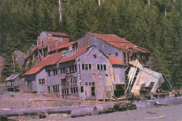
Image 5. Abandoned Salt Chuck mine mill, mid 1970’s. The mill was a three story wooden building that housed the machines used to process the ore before shipment to a refinery. The mill’s first year of production was 1916. It was able to process 30 tons a day but production rates were much lower. (P. Roppel, 1991)

Image 6. Ball mill. Steel balls crushed the ore into fines and the minerals were floated and separated from waste material. (D. Sylvia, 2017)

Image 7. Hardinge classifier. Divided the ore by concentrating the minerals at the bottom and floating the gangue to the top. Used in conjunction with the ball mill to process the fines. (D. Sylvia, 2017)
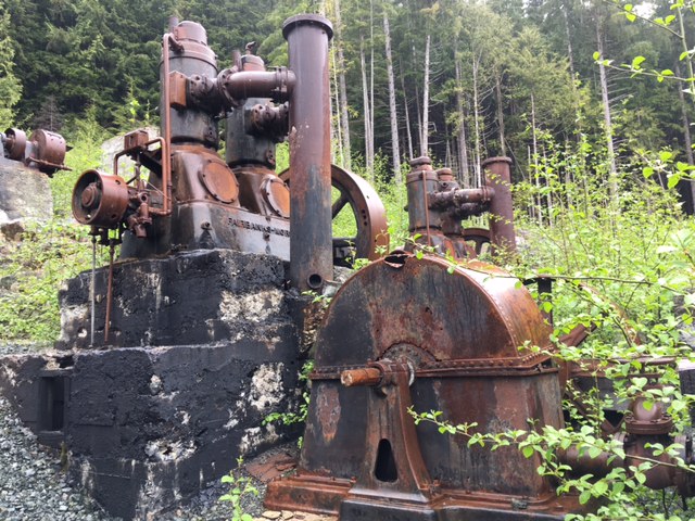
Image 8. Pelton water wheel. The wheel powered the mine’s air compressors and generators. Water from nearby Power Lake was delivered to the water wheel via stave-constructed water lines. (D. Sylvia, 2017)
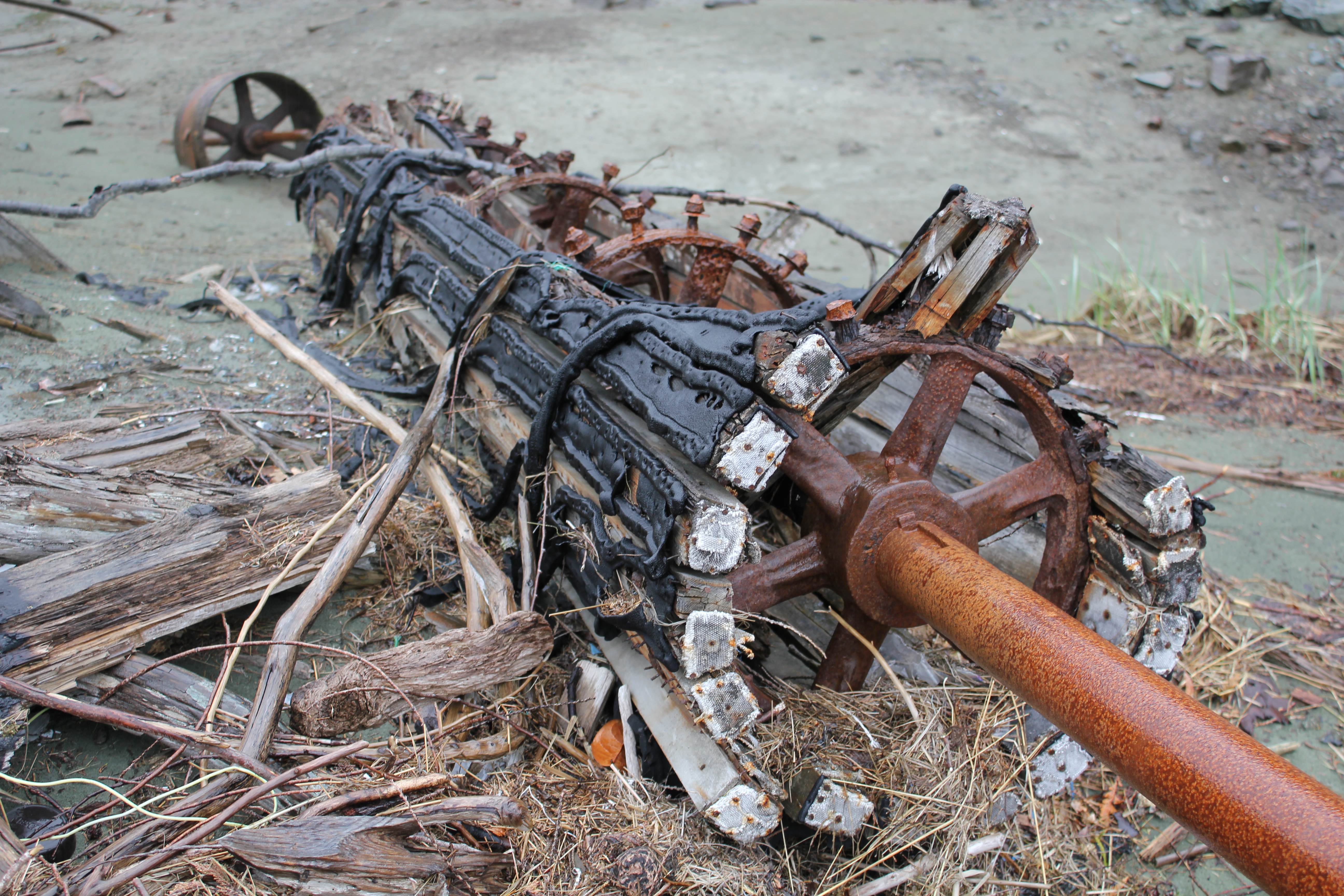
Image 9. Water line section. Remnant section of wooden stave water line used to deliver water to the Pelton water wheel from Power Lake – intertidal zone near mill site. D. Sylvia, 2017.

Image 10. Fairbanks Morse diesel engine. The engine was connected to a generator that supplied power to lights and electric motors within the mill. (D. Sylvia, 2017)
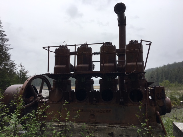

Images 11a and b. Fairbanks Morse diesel. These are two of the units used to power the mill’s equipment. (D. Sylvia, 2017)
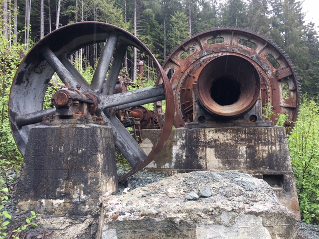
Image 12. Ingersol-Rand air compressor. This compressor was used during the floatation process. (D. Sylvia, 2017)
The mill was modernized and its capacity increased over the next few years. In April 1920, the mine shipped a record 45 tons of concentrate that assayed 44% copper, 2 ounces gold, 14 ounces silver, and “some” palladium. Additional capital was needed to continue operations. Consequently, in October 1920 Chilberg reorganized as the Platinum-Palladium Producing Company. Although the mine continued to produce ore, the price of palladium fell. Competition from mines in Russia and Columbia forced the mine to close and enter into receivership in 1921. Chilberg leased the mine and re-incorporated as the Alaska Palladium Company. The mill was, again, modernized and enlarged, new bunkhouses and cottages were built. The mine was very active for 1923 through 1926, employing 50 men. The Alaska Weekly newspaper’s 8 January 1926 edition stated that the Salt Chuck mine was the largest producer of palladium in the United States, annually producing between 4,000 and 4,500 ounces (Roppel, 1991). Sharply lower palladium prices and foreign competition again forced the mine to close in 1925 and enter into foreclosure.
The property was optioned and leased by other companies following its closure in 1925. The Alaska Gold and Metals Company jointly worked the Salt Chuck and nearby Rush and Brown mines until 1941 when operations were suspended. During World War II, the U.S. Geological Survey and the U.S. Bureau of Mines studied the deposit in detail, drilled 13 holes, and reinterpreted 7 holes that had been drilled earlier by Solar Development Company (Gault, 1945; Holt and others, 1948; Gault and Wahrhaftig, 1992). Efforts to renew operations in 1947 failed. Based upon coring results, mentioned earlier, the US Bureau of Mines concluded that the remaining ore was less than the amount already removed. The Alaska Gold and Metals Company leased the property for a short time and completed additional assessments. However, the company was involuntarily dissolved in 1968. Subsequently, the staked claims on the unpatented Salt Chuck Mine and Newmont Mining Company completed a coring program on both the Salt Chuck and Rush and Brown claims but did not pursue reopening the mines. In 1985, Orbex Minerals, Ltd. explored the area. Others have staked claims but have allowed them to lapse.
According to Gault (1945), the total production from the Salt Chuck mine (based upon incomplete records) from 1907 to 1941 was about 300,000 tons of ore. The ore averaged 0.9 percent copper, 0.01 ounce of gold per ton, 0.10 ounce of silver per ton, and 0.05 ounce of palladium per ton. Today, the site is a lonely, abandoned place, often cold and rainy. On our recent visit to the old mine; we could only imaging how hardy and determined the early miners must have been.
The Salt Chuck mine was placed on the Environmental Protection Agency’s National Priority List in 2009 for Superfund cleanup.[7] The Alaska Region Forest Service conducted a $2.7 million cleanup in 2011 within the mill area on USFS administered lands. However, contamination is in the tailings that are in the State-owned intertidal area. The site is managed by the EPA as a Superfund site. The site is quiet today belying the high activity of the men and machines that once labored here to extract the earth’s riches.
The trail into Salt Chuck affords a pleasant, short hike along lakes that take one through an old second growth stand of hemlock, red cedar, and Sitka spruce. Remnants of the mining operation are seen near the mill site. A few images taken during my hike into the mill site follow (Images 13, 14, 1nd 15).

Image 13. Salt Chuck mine trail. The trail is adjacent to several small, connected lakes. This and the other following trail images were taken in mid-May. (D. Sylvia 2017)
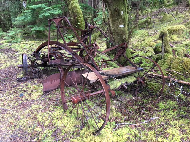
Image 14. Horse drawn road grader. This road grader was used to maintain access roads to the Salt Chuck mine. According to the US Forest Service’s interpretive sign, the Austin Manufacturing Company in Chicago, IL built it between 1900 and 1934. (D. Sylvia, 2017)

Image 15. Salt Chuck trail. A variety of ferns carpeted most areas along the trail. (D. Sylvia 2017)
The mine may again see a resurgence in activity. Pure Nickel, Inc., a Canadian mineral exploration company, leased the 146 contiguous federal lode mining claims collectively known as the Salt Chuck mine. Based upon results of their 2014 drilling program, Pure Nickel Inc. stated that Salt Chuck Property hosts numerous mineralized structures that locally exhibit elevated gold and copper values[8]. Perhaps the mine’s final chapter may not yet be written.
Acknowledgements
This blog drew heavily from the work published by the Alaska historian, Patricia Roppel, in her 1991 work, Fortunes from the Earth, referenced below.
Thanks to my wife, Lavenia Sylvia, for helping as a visual observer during sUAS flights and most importantly helping feed the voracious gnats on our last visit to the mine site.
References
Brew, D.A., 1996, Geologic map of the Craig, Dixon Entrance, and parts of the Ketchikan and Prince Rupert quadrangles, southeastern Alaska: U.S. Geological Survey Miscellaneous Field Studies Map MF-2319, 53 p., 1 sheet, scale 1:250,000.
http://pubs.er.usgs.gov/publication/mf2319
Buddington, A.F., and Chapin, Theodore, 1929, Geology and mineral deposits of southeastern Alaska: U.S. Geological Survey Bulletin 800, 398 p.
http://pubs.er.usgs.gov/publication/b800
Eberlein, G.D., Churkin, Michael, Jr., Carter, Claire, Berg, H.C., and Ovenshine, A. T., 1983, Geology of the Craig quadrangle, Alaska: U.S. Geological Survey Open-File Report 83-91, 52 p.
http://pubs.er.usgs.gov/publication/ofr8391
Environmental Protection Agency, 2009. Salt Chuck mine on Alaska’s Prince of Wales Island proposed for Federal cleanup list:
Gault, H.R., 1945, The Salt Chuck copper-palladium mine, Prince of Wales Island, southeastern Alaska: U.S. Geological Survey War Minerals Report for Federal War Agencies, 19 p.
Gault, H.R., and Wahrhaftig, Clyde, 1992, The Salt Chuck copper-palladium mine, Prince of Wales Island, southeastern Alaska: U.S. Geological Survey Open-File Report 92-293, 5 maps, 24 p.
http://pubs.er.usgs.gov/publication/ofr92293
History Link.org, Chilberg, John Edward (1867-1954), 04 June 2017. http://www.historylink.org/File/8753
Holt, S.P., Shepard, J.G., Thorne, R.L., Tolonen, A.W., and Foose, E.L., 1948, Diamond drilling at Rush and Brown copper mine, Kasaan Bay, Prince of Wales Island, southeastern Alaska: U.S. Bureau of Mines Report of Investigation 4349, 7 p.
Loney, R. A., and Himmelberg, G. R., 1992, Petrogenesis of the Pd-rich intrusion at Salt Chuck, Prince of Wales Island: an early Paleozoic Alaskan-type ultramafic body: Canadian Mineralogist, v. 30, p. 1005-1022.
Mertie, J.B., Jr., 1921, Lode mining in the Juneau and Ketchikan districts: U.S. Geological Survey Bulletin 714-B p. 105-128.
http://pubs.er.usgs.gov/publication/b714B
Page, N.J., Clark, A.L., Desborough, G.A., and Parker, R.L., 1973, Platinum-group metals, in Brobst, D.A., and Pratt, W.P., eds., United States mineral resources: U.S. Geological Survey Professional Paper 820, p. 537-545.
http://pubs.er.usgs.gov/publication/pp820
Roppel, Patricia, 1991, Fortunes from the earth: Manhattan, Kansas, Sunflower University Press, 139 p.
Sainsbury, C.L., 1961, Geology of part of the Craig C-2 quadrangle and adjoining area, Prince of Wales Island, southeastern Alaska: U.S. Geological Survey Bulletin 1058-H, p. H299-H362.
http://pubs.er.usgs.gov/publication/b1058H
Smith, P.S., 1926, Mineral industry of Alaska in 1924: U.S. Geological Survey Bulletin 783-A, p. 1-30.
USGS, Mineral Resources On-Line Spatial Data, Alaska Resource Data File, 04 June 2017. https://mrdata.usgs.gov/ardf/show-ardf.php?ardf_num=CR049
Wright, C.W., 1915, Geology and ore deposits of Copper Mountain and Kasaan Peninsula, Alaska: U.S. Geological Survey Professional Paper 87, 110 p.
http://pubs.er.usgs.gov/publication/pp87
Blog Notes
[1] The Salt Chuck mine, or claims that were eventually incorporated into the property, have been given several names, including the Goodro, Stevens, Joker, and Leibrant.
[2] Palladium is a rare, platinum group metal that today largely is used in catalytic converters.
[3] The Salt Chuck mine is in a mafic pluton about 4.5 miles long and up to a mile wide in outcrop. The pluton consists of gabbro, clinopyoxenite, and diorite. It intrudes metamorphosed volcanic and sedimentary rocks of the Descon Formation of Silurian and Devonian age (Eberlein and others, 1983; Brew, 1996). The pluton has been dated at 429 Ma (Loney and others, 1987). The deposit consists chiefly of bornite, chalcopyrite, and platinum-group minerals that occur as disseminations or as veinlets and irregular masses (pods) in the gabbro and clinopyroxenite (Wright 1915; Mertie, 1921; Buddington and Chapin, 1929; Gault, 1945; Sainsbury, 1961; Page and others, 1973). The workings of the mine are shown in detail on the maps and diagrams of Gault (1945) and Gault and Wahrhaftig (1992). The deposit was mined in three glory holes connected by an intricate network of raises, stopes, and drifts at three levels. The workings connected to a main haulage tunnel at the 300-foot level that led to a mill (described in detail by Mertie, 1921) on the shore of the salt chuck at the head of Kasaan Bay. Several references are included at the end of this blog that provide additional information on the Salt Chuck and adjacent mines’ geology and production.
[4] USGS, Mineral Resources On-Line Spatial Data, Alaska Resource Data File, 04 June 2017. https://mrdata.usgs.gov/ardf/show-ardf.php?ardf_num=CR049
[5] Several annual reports on the mineral history of the Territory of Alaska were prepared by the US Geological Survey prepared by Philip S. Smith during the period 1926 through 1942 are available online – some are incomplete/very incomplete. I have included the 1926 report in the reference section of this blog. The importance of the Salt Chuck mine (Goodro mine) is evident in what is written in this report (see the Platinum Metals chapter, page 24).
[6] Chilberg became involved in Alaska business ventures during the Klondike gold rush. He previously ran a steamship service between Seattle and Central America
[7] The Alaska Department of Health and Social Services and the Agency for Toxic Substance and Disease Registry concluded that traditional use, i.e., harvesting a variety of clams and vegetation from the Salt Chuck Mine site is not expected to harm health (CSTE Conference Abstract, June 20, 2016. https://cste.confex.com/cste/2016/webprogram/Paper7088.html
[8] See Newsfile Corporation, September 11, 2014. Their announcement may include forward looking statements, 09 June 2017. https://www.newsfilecorp.com/release/11637/Pure-Nickel-Announces-Results-for-Salt-Chuck-Drilling-Program – .WTtIw8aZO8V

Leave a comment